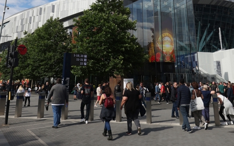
Please note we have a restricted bag policy at the Stadium. Bags larger than A4 (21cm wide x 30cm long) will not be permitted in.

Getting to Tottenham Hotspur Stadium
The easiest way to travel to Tottenham Hotspur Stadium is by public transport. Below is a guide to all the services
For event-specific travel updates, please select your event from the 'What's On' menu.
The Stadium is served by four train stations.
White Hart Lane
Approx. 5 minute walk - that's more or less 500 steps for those of you with fitness apps. This station is fully accessible.
Northumberland Park
Approx. 10 minute walk to the Stadium or 1,000 steps.
Tottenham Hale
Approx. 25 minute walk to the Stadium or 2,500 steps
Seven Sisters
Approx. 30 minute walk to the Stadium or 3,000 steps.
The Stadium is well-served by TfL buses, albeit on event days some services may be diverted during the road closure period.
Bus diversions are minimised, so they are back operating on the High Road as soon as possible after events.
Before and during events, services that normally run up and down the High Road (149, 259, 279 and 349) are diverted to the east of the Stadium at Lansdowne Road, re-joining the High Road at the Northumberland Park junction.
There are no road closures on non-event days, so if you are coming for our Stadium Tours, The Dare Skywalk or to visit the Tottenham Experience on a regular day, these will not affect you.
Download TfL buses map → (this map shows all the TfL bus stops around the Stadium)
If you’re feeling fit then why not cycle?
We encourage spectators to cycle to Tottenham Hotspur Stadium. There is ample cycle parking around the Stadium and at the Tottenham Community Sports Centre on the High Road.
Cycle Superhighway 1 begins on Church Road immediately opposite the Stadium and runs to Liverpool Street station.
There is both on-street and off-street cycle parking provided in the local area around the Stadium. Please see the cycle map for the locations.
Cycling equipment such as puncture kits and removable seats will be allowed into the Stadium. Helmets (but not those with a full mask attached) will also be permitted.
Download cycling superhighway route map → Cycling superhighway route map shows the route from Liverpool Street to Tottenham.
Download Cycle Parking Map → Cycle Parking Map shows where cyclists can park their bicycles in Tottenham.
There is no public car park at the Stadium which is also within a large Controlled Parking Zone (CPZ).
EVENT DAYS
The road closures on event days also mean that, if you choose to travel by car, you will not be able to exit any car parking facility within the road closure area for one hour after the event finishes.
Therefore, in most cases, we discourage fans from driving to the Stadium on event days, so please explore your public transport options before travelling.
Event day road closures prevent spectators from being dropped-off or picked-up close to the Stadium. If you need to use a taxi or private hire vehicle, we recommend you are dropped-off and / or picked-up at least a 10-minute walk (0.5 miles) away from the Stadium.
NON-EVENT DAYS
Free parking (including Blue Badge parking bays) is available in Sainsbury's Tottenham on non-event days and is a 5 minute walk from the Tottenham Experience. On non-event days parking is free up to a maximum of 3 hours, but guests are advised to check the latest parking restrictions upon arrival.
Carbon neutral coach travel is available from Big Green Coach on most event days.
Big Green Coach is the official and exclusive coach travel partner to Tottenham Hotspur Stadium.
Click here to see the available coach travel options from Big Green Coach.
The Stadium currently provides a free pre-booked shuttle bus service, which is accessible and available for all fans. This service provides a high capacity, high-frequency service between the Stadium and Alexandra Palace (Great Northern Services) and Wood Green (Piccadilly Line) stations.
Although the service is free for all fans, you will need to register via the link below before booking and present your e-ticket to bus staff before entry onto a shuttle service.
Please note that some roads closest to the Stadium will be closed before, during and immediately after events to make it safe for spectators, local residents and businesses and to ensure emergency services can access the area. Please check the road closure maps for more information.
Love Lane and Whitehall Street also have all parking bays suspended on a event day and are closed for up to one and half hours after an event to cater for queues at White Hart Lane station. For one to two hours after a event, Leeside Road is one-way eastbound and Willoughby Lane is one-way northbound, from its junction with Willoughby Park Road.
Event day parking controls operate within this area.
For more detailed information on how the road closures work, take a look at the maps below below.
Road Closure Map - Pre Event
Pre-event or match
Download our pre event road closures map
Road Closure Map - Phase 1
Two hours before the match or doors for your event.
View full map
Road Closure Map - Phase 2
One hour prior to the start a match and up to 15 minutes after.
View full map
Road Closure Map - Phase 3
During an event or match
View full map
Road Closure Map - Phase 4
15 minutes prior to final whistle and up to one hour post-event or match.
View full map